
Maps and GPX
Village to Village Camino Guidebooks include dozens of useful day stage and city maps, and pair with the Ride With GPS app for offline trail navigation and a full GPX file set to offer assistance in planning and navigational aid.
Camino Francés: Download GPX stage tracks
Camino Portugués: Download GPX stage tracks
Camino del Norte: Download GPX stage tracks
Camino Primitivo: Download GPX stage tracks
Smartphone GPS Applications
Smartphone apps drain your battery even quicker than normal, but can be a great backup and cost-effective option to a dedicated handheld GPS. Be sure to put your phone in airplane mode to save battery, and consider carrying an external supplemental battery pack.
Ride With GPS
Ride With GPS offers a variety of navigational tools, including navigation from your smartphone and route study and planning from detailed route maps on the site’s websites on your home computer. V2V is proud to partner with RWGPS to offer these services for our users.
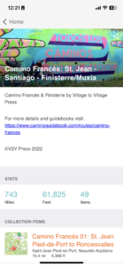
- Download the RWGPS app and create an account (Apple or Android). V2V Trails routes offer free navigation and offline use without a paid, premium RWGPS subscription.
- Adding our routes to your RWGPS collection: “Pin” routes to your personal collection (use the “Pin” button on the top left of the sidebar on website, “Save” button on the app). This will add and sync the route to your RideWithGPS account for future reference on and off the trail.
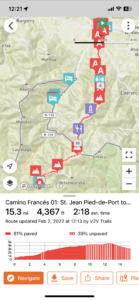
- For offline navigation and reference on the trail, you can also save V2V Trails RWGPS routes to your phone’s app while on wifi or in your home country before the trip. This will work without an active data plan, even with your phone on Airplane mode.
- On your home computer’s larger screen, view the V2V route collections (route-specific links above). Explore different basemap options (OSM Outdoor recommended), route detours and alternates, and elevation grades.
- To download a GPX file, open a route’s stage that you wish to view and look for the orange “Export GPS File” button. You can then input this GPX file into the GPS device of your choice.
- Use kilometers or miles, depending on your preference. Visualize which sections of each day stage are paved and unpaved.
- For bicigrinos, cyclists and MTB users, turn on the “Global Heatmap” layer to see where others are riding most, either detour onto those paved road off of rocky sections of the trail, or to avoid where others are going!
Gaia GPS
Gaia GPS is another popular smartphone mapping and navigation app (subscription levels vary). Gaia also works without having a cellular signal, does not incur data roaming charges (if this is turned off on your phone) and utilize free topographical map base maps for offline viewing (based on OSM maps).
To transfer a GPX file to Gaia GPS app on your phone, either:
- Email it to yourself as an an attachment, open the file in your phone’s mail app, and direct it to open in Gaia GPS (quicker
- Import it using Finder (MacOS10.15) (be sure to have latest MacOS version, and phone connected with a cable)
- Click the iPhone icon in the left toolbar under “locations.” Enable trust between computer and device.
- On the top toolbar, click “Files” to open panel below.
- Scroll down to File sharing at the bottom of the page, click on “Gaia GPS”
- Drag your GPX file into the “Gaia GPS”
- Eject your phone, open the Gaia GPS app, and find the file under “tracks” in the menu.
- Import it using iTunes (10.14 and older) (be sure phone is connected with a cable)
- Click the iPhone icon on the top toolbar
- On the left sidebar under settings, click “Apps” to open panel on right
- Scroll down to File sharing at the bottom of the page, click on “Gaia GPS”
- Drag your GPX file into the “Gaia GPS Documents” box on the right side or open it using the “Add…” button
- Eject your phone, open the Gaia GPS app, and find the file under “tracks” in the menu.
Please note that the distances you record while walking with your GPS app may be longer than the actual distance of the route listed in the guidebook and its GPX tracks, which have been carefully edited to measure the length of the camino along a straight line beginning and ending at the town’s primary albergue. The increased distance most people record while walking is due to the culmination of slight detours into cafes or points of interest, geolocation noise while not moving, and the varied accuracy of individual GPS units which decreases in areas without an unobstructed view of the sky (like tall city buildings).
Topographical Trail Maps
Most camino hikers do not carry detailed maps, as the route is very well marked. The stage maps provided in our guidebook should be more than enough to provide accurate navigation, amenities, and points of interest. These maps are a combination of GIS contour data, GPS recordings of the path itself, and added detail as relevant. Map scales range, designed to maximize space efficiently per page. Maps list amenities including overnight lodging, restaurants/cafes and supermarkets. Full amenities are listed in town boxes in text and elevation charts.
GPS data © Camino Guidebooks, Village to Village Press, LLC. GPS data is available for personal and recreational use only, and may not be used for any commercial purposes.